Search the Community
Showing results for tags 'shadings'.
Found 6 results
-
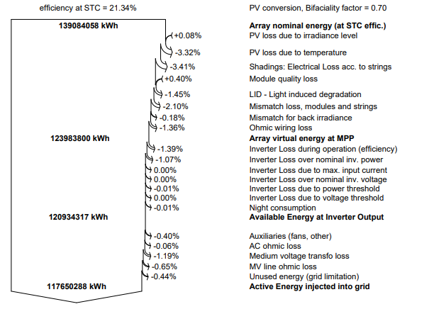
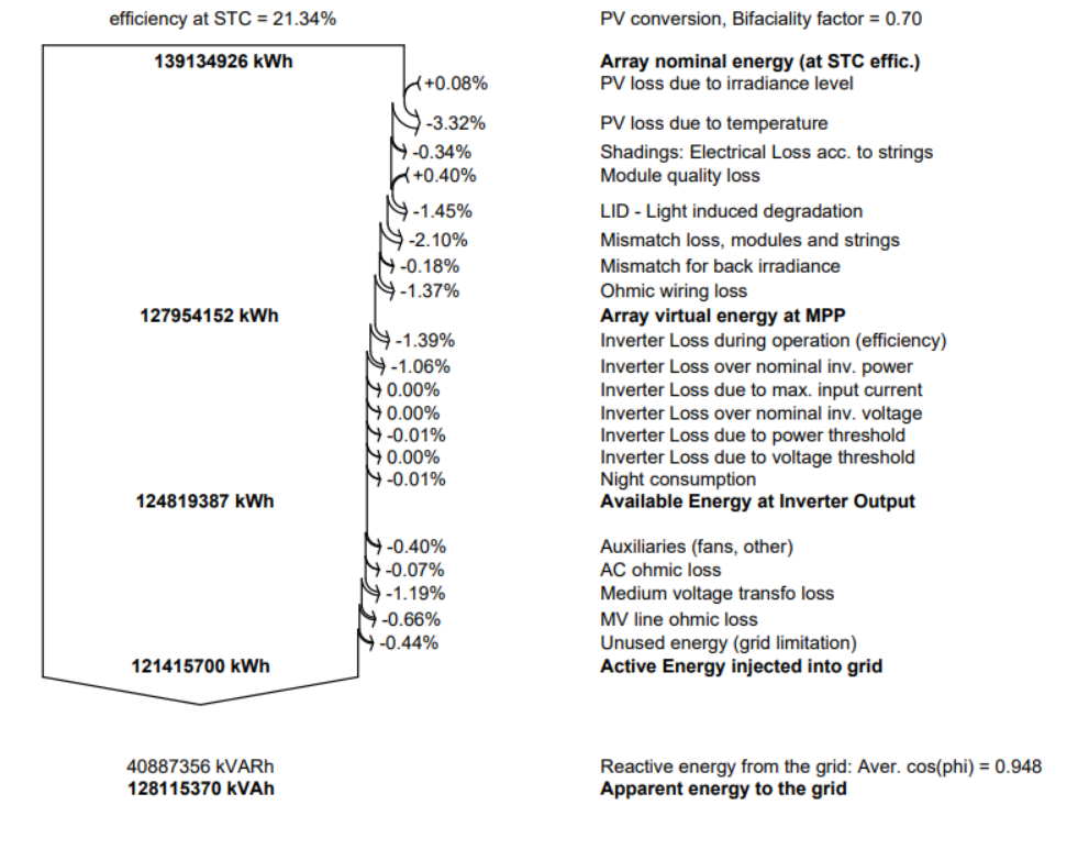
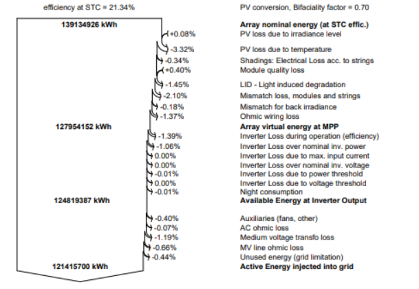
 Hi all. With the recent update of PVSYST to the 7.4.0 version I have see that the shading electrical losses are too much higher comparing with the previous version. Launching the same simulations of a PV plant (using the same parameters and the same Near Shadows scene, the shadings losses goes from -0.34% (in 7.3 version) to -3.41% (in the version 7.4). Could it be a possible bug? Is is possile to the new version overestimate this kind of losses? Near and far shadow losses factors change too but the value are similar this only happens with the shading electrical losses. Thank you very much.
-
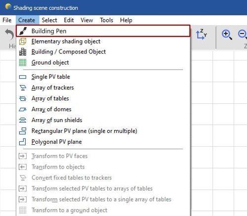
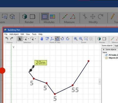
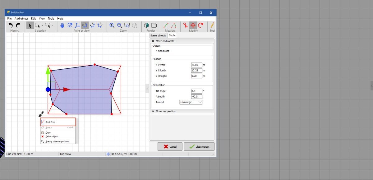
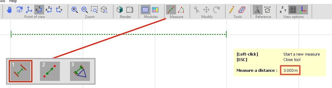
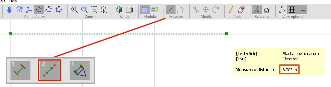
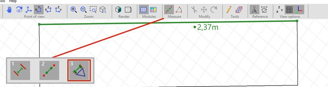
 1 - Model Pen (Building Pen) The idea is to have a free-draw mode for creating complex or unusual building shapes, with the ability to adjust the height, length, and—if possible—the curve “resolution” (i.e., the number of lines used to form curves, similar to a cylinder’s segmentation). Ideally, this tool could be integrated into the Building / Composed Object section. Personally, I’ve found it difficult to create certain shapes and structures that could be done much faster with this improvement, especially roofs. Design Suggestion: Using software like SketchUp or SolarEdge makes this process easier because they include a pen tool and are not limited to predefined models, allowing for more flexible scene composition. If this feature were implemented—considering any software limitations—it would be extremely useful to combine it with the ability to configure any roof shape based on a drawn outline, merging the best features from other tools in one place. Design Example: This tool could work in two alternative ways: Building/Object Pen – Functions like a freehand pen to draw custom shapes. Building/Object Cropper – Used only to cut or reshape predefined objects/buildings into the desired form (simpler from a general perspective). 2 - Magnetic Measure Mode This idea is much simpler than the previous one 😄. The goal is to customize the measurement tool to work faster and more accurately in determining dimensions. It could have three modes: 1. Full Magnetic Measure (Grid-Based) – Snaps measurements to whole number values (e.g., 1m, 24m, 87m). 2. No Magnetic Measure (Standard) – Works as the current free measurement tool. 3. Full Magnetic Measure (Object-Based) – Click any object edge/line to automatically display its length. That’s all for now. I’ll be back with more ideas and suggestions. I really enjoy using this software and wish the best to its developers. Thanks for your attention!
-
 Hi all, I have to run a simulation in PVsyst in order to compute the shadowing impact created by the presence of three wind turbine aerogenerators located within the layout design of an agrivoltaic PV plant. To do so, I am well aware of the fact that I can import in the PVsyst tool Near Shading 3D scene a .pvc file (from PVcase) of the layout which can include the 3D shadowing items of the 3 wind turbines with the aim to compute in the simulation the impact of the shadows generated by those turbines with respect to the PV plant producibility. In this regard, I would like to know: - if the software quantifies such shading losses in the loss diagram under the voice Near Shading Losses. If not, please clarify in which voice they are allocated in the loss diagram -if there is some kind of way to compute the impact of the shadings generated by the wind turbines in a daily/hourly/monthly formats to understand for example through the year in which periods of time (days, hours) the shading effects is more relevant Please let me know if there is the need of any additional information that could be helpful to provide an answer to my questions. Thank you in advance. Vinh
 -
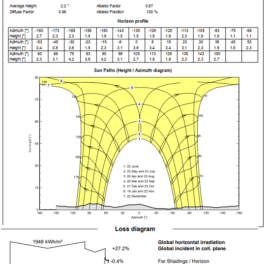
 Hello, I have two projects in the same location and the losses horizon shading difference is 1.4%. The horizon profile is similar. In the first, I have the following factors: Albedo factor = 0.87 Diffuse factor =0.96 The horizon losses is 0.4%. In the second, I have the following factors: Albedo factor = 1.00 Diffuse factor = 1.00 The horizon losses is 1.8%. Question: 1) How do these factors affect the shading calculation? 2) How can these factors be defined? 3) Where can these factors be set in PVsyst? Thank you!
-
Hello forum users, i am doing some research on the various Horizon sources available. i have chosen some meteo data i have used for previous projects and i would like to do a series of analysis for each one of them using: 1 - SolarGIS Horizon profile 2 - Meteonorm Horizon (from PVsyst web sources) 3 - PVGIS Horizon (from PVsyst web sources) my goal is to: compare the "far shading losses" and the Horizon line drawings considering the different Horizon data so to have a general overview of the differences between the Horizon datasets; of course my research will also include the study of the manuals and theory behind the definition of the Horizon profile provided by each one of the three Meteo database. i would like to raise a couple of questions: how far has to be an obstacle to be actually considered in the far shadings? considering the high dependency of the horizon from the exact geographical coordinates, are there any suggestion on the horizon profile choice regarding big PV plants? has someone of you undergone some similar studies? have you found some interesting results? also, considering point 2, a question for the software developers: are you considering a possible software update that would allow the user to set different horizon profiles, perhaps linking a single profile to a single subfield? thank you very much in advance for your contribution! Davide
-
Hi, Just a couple of ideas: 1. It would be useful if one could import geo-referenced shape files for definition of zones. More often then not these areas are received either as an Autocad or Google Earth Kml or Kmz file. Having the possibility to import those will directly specify the project location and will make zone editing a breeze; 2. Since a lot of effort can be put into fine-tuning the shading scene it would be very useful if the said scene could be exported into a CAD program for creation of necessary drawings required for permitting and such. Alternatively, a layout export, at least, would be very handy Sincerely, iulian