Search the Community
Showing results for tags 'meteonorm'.
Found 4 results
-
Hello forum users, i am doing some research on the various Horizon sources available. i have chosen some meteo data i have used for previous projects and i would like to do a series of analysis for each one of them using: 1 - SolarGIS Horizon profile 2 - Meteonorm Horizon (from PVsyst web sources) 3 - PVGIS Horizon (from PVsyst web sources) my goal is to: compare the "far shading losses" and the Horizon line drawings considering the different Horizon data so to have a general overview of the differences between the Horizon datasets; of course my research will also include the study of the manuals and theory behind the definition of the Horizon profile provided by each one of the three Meteo database. i would like to raise a couple of questions: how far has to be an obstacle to be actually considered in the far shadings? considering the high dependency of the horizon from the exact geographical coordinates, are there any suggestion on the horizon profile choice regarding big PV plants? has someone of you undergone some similar studies? have you found some interesting results? also, considering point 2, a question for the software developers: are you considering a possible software update that would allow the user to set different horizon profiles, perhaps linking a single profile to a single subfield? thank you very much in advance for your contribution! Davide
-
 The meteonorm 8.1 database has hourly values of ambient temperature. Does PVsyst calculate the Cell temperature using the ambient temperature value at the specific time during the simulation or it uses the monthly average for all days? I mean does it calculate the cell temperature only during daylight or it merges all heat transfer throughout the year, day and night.
 -
I have found the data provided in latest Meteonorm 8.1 have a huge difference in GHI. This seems to be an error in data and drastically reduce solar generation. For example, for the Lahore City the average GHI in previous meteonorm versions and other data sources are around 1700Wh/m² while in Meteo 8.1, it is around 1525kWh/m² Similarly, For the Islamabad Region the average GHI in previous meteonorm versions and other data sources are around 1735Wh/m² while in Meteo 8.1, it is around 1550kWh/m² Another example In Khanewal-Punjab region the average GHI in previous meteonorm versions and other data sources are above 1800Wh/m² while in Meteo 8.1, it is around 1650kWh/m² Do we have any option to get previous metenorm data in latest version? or is there any suggestion to overcome this issue?
-
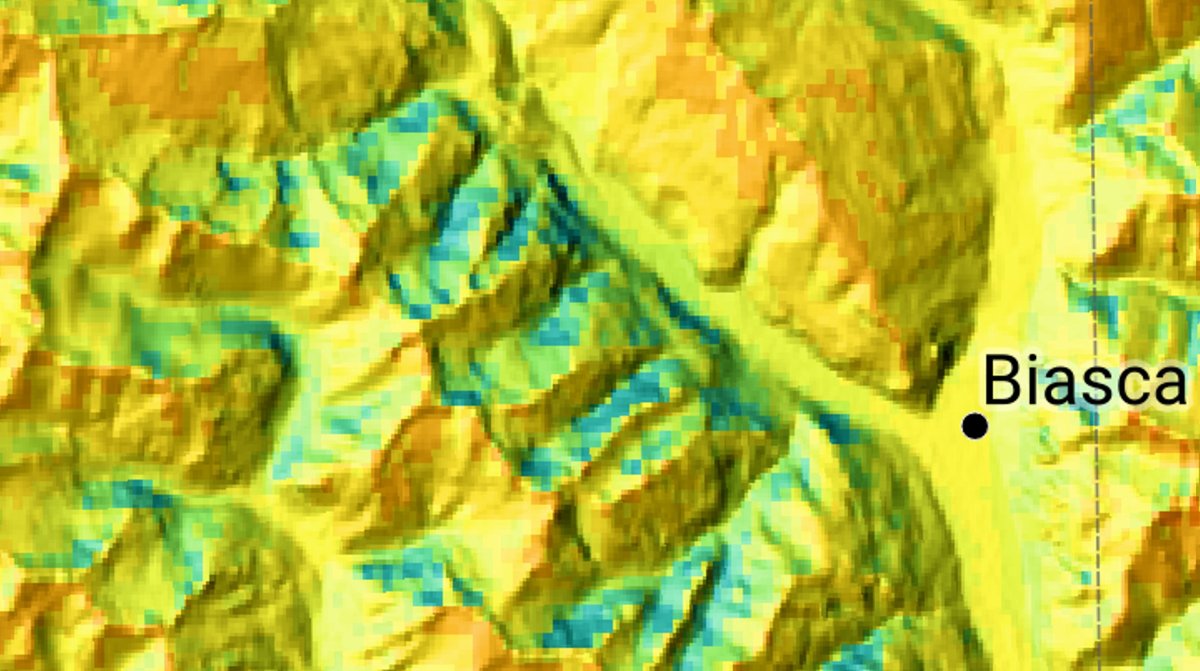
 Hi dear Forum users I'm using PVSyst since a while now as a Student, but only now got into the topic of GHI Data generation (and also (synthetic) TMY). I always thought that GHI was calculated on a flat horizon model and has to be considered with the Horizon in PVSyst (subtracted). But when I saw the GHI map from Meteonorm of Switzerland, it seems that this is already taken into account, since north oriented side of a Mountain has much smaller values in GHI than south oriented. Now that I see it, it seems to make sense, but I wanted to make sure I don't miss a point. My thoughts: — When I get the monthly values of Meteonorm, the irradiation seems to already be the effective irradiance to hit this spot on the map, so the horizon has already been considered. — When I generate a synthetic TMY file, it doesn't take the horizon into account and spreads the hours throughout the day, even at times, where there wouldn't be a direct beam. — And when I subtract the horizon with the built-in function, I subtract it again from the data. Do you agree? I'm interested in your opinions. With real measured hourly data it wouldn't make a difference, because the measuring device would not measure a high GHI in the shadow anyway and therefore nothing could be subtracted in the simulation. It still wouldn't be necessary, but wouldn't do any harm. So the problem lies in the synthetic TMY generation combined with the horizon function. I even summed up the whole Hourly TMY to make sure it fits the yearly values. Only the partial near/shading would then be appropriate. Best, Rafael