LauraH
-
Posts
36 -
Joined
-
Last visited
Everything posted by LauraH
-
Trackers appear as "polygonal fields" -- problem using PVC scenes
LauraH replied to LauraH's topic in Problems / Bugs
For the same objects, I get the message "For 16 fields in the 3D scene, the orientation is not attributed." Not being sure whether these objects are being treated as trackers, I'm not inclined to spend the time trying to fix this, but this is an error, not a warning. Is there any way I can have PVsyst ignore this? I could just delete those objects. It's a big shading scene. -
Trackers appear as "polygonal fields" -- problem using PVC scenes
LauraH replied to LauraH's topic in Problems / Bugs
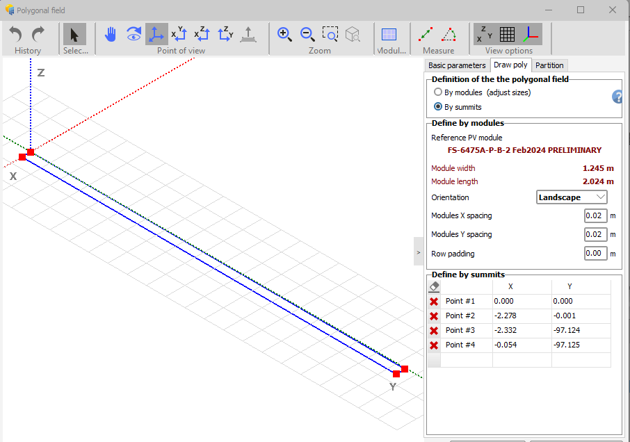
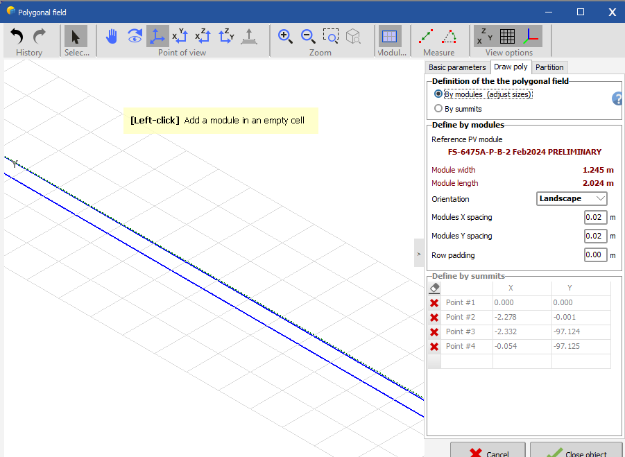
Adding figures. This is the original appearance.This is after going to "by modules."
-
When I read in the most recent PVC files provided by our CAD team, some of the trackers are treated as "polygonal fields" instead of trackers. What does this mean and what can I do about it? I see that there is an option to define the polygonal field "By modules" in the "Draw poly" tab but it's not clear what this does. Even if I check that box and define partitions, no modules appear in any of the graphical representations and the type of object doesn't change, so I don't know whether this has solved the problem. Unfortunately, our design team doesn't have time to investigate this thoroughly, so I'm looking for a solution that can be implemented within PVsyst. Thanks.
-
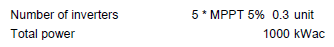
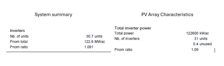
Hi, Please stop rounding numbers to 0.1 and give us 0.01. Rounding makes for inconsistent values, and it's not possible to know whether a calculation has been done correctly. (I think sometimes a calculation does use the parameter value as entered, but the report shows it in tenths.) I've been unhappy with this for a long time, but I am motivated to write now because of difficulty I'm having interpreting the representation of mixed blocks as broken down over multiple MPPTs. There are 20 MPPTs used, so a resolution of 0.05 is needed. 75% of the entries are shown rounded and the totals don't add up. (See illustrations.) Thanks.
-
Hi, I am modeling a complicated array that uses 6 different modules, some mono- and some bifacial. We are supposed to run strings of as many as two bin classes of monofacials and one class of bifacials all into the same inverter. This inverter model (rated at 4000 kW) has a single MPPT. On top of everything else, the inverter loading ratio is 1.5, so clipping will be important. What is the best way to represent this? I have read the information about "power sharing" in the manual and watched an instructional video. These both centered on how to represent multiple MPPTs in the same inverter separately (which is the opposite of power sharing). I know two ways to combine modules of the same type but different bin classes This is by creating an "equivalent block" by picking the dominant module and adjusting either the number of modules or MQF to get the correct DC capacity. The other is to break up the inverter. The former has the advantage of treating all of the DC power together when computing clipping. The second is more explicit, but would seem to miscalculate the clipping. I know one way of mixing mono- and bifacial modules. That is creating an "equivalent block" where the capacity of the bifacial modules is multiplied by an effective received irradiance factor and then following the standard "equivalent block" method above using a monofacial module. Maybe the two types can just be combined in PVsyst 8? Otherwise you can break up the inverters again and put the monofacial and bifacial modules in different variants. (Again, this would seem to compute clipping incorrectly.) So back to the original question: What would be the recommended/most accurate way to model these inverter blocks? Thanks. Too many Frankenstein systems these days!
-
Why are diffuse integrals calculated for every run?
LauraH replied to LauraH's topic in Shadings and tracking
That would be great. -
Why is the diffuse shading information computed for every run, unlike the direct shading? Can't this information at least be held in the active memory as long as you're working on the same variant? I'm tweaking my loss terms and every time I rerun, PVsyst takes the time to build the diffuse integrals again. I can understand if you don't want to save it in the export, but while you're working would be nice. Thanks.
-
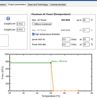
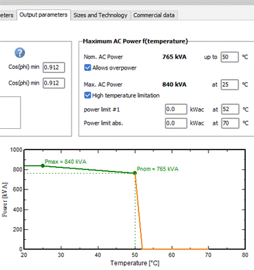
For a TMEIC inverter we are using, the enhanced power you mention doesn't show up in the plot unless we check "Allows overpower." Is that usually the case?
-
New tool Shading scene (ground objects)
LauraH replied to Barbadori's topic in Shadings and tracking
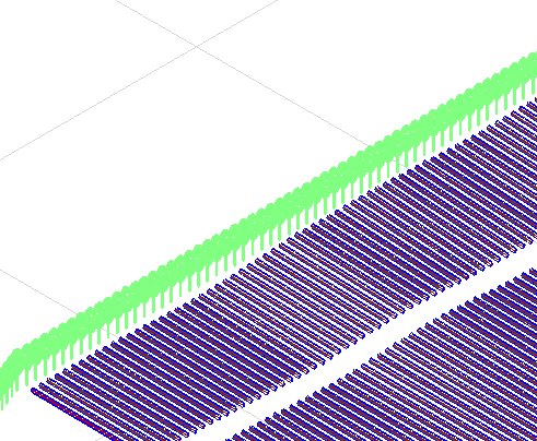
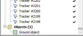
I received a shading scene in which all of the trees are included as a single ground object. This seems like an incredible way to represent many trees as one object. They do seem to throw shade. Q: If trees shouldn't be included in the ground objects, why are those options given for a PVC import? It looks like the tops of the trees will be considered the ground if you select the first box. Nevertheless, individual trees are depicted in the shading scene. Second screen shot shows that no trees are included in the object list. Thanks.
-
This all seems like a lot more work than having the project export include a SIT file. Why can't we just have that? Normally, when passing an export file to someone else, we copy the SIT file from the data directory and send that as well. It's not a good use of time and is easy to forget.
-
There is no corresponding SIT file in the Sites folder. That's the problem. I got the project file from another user and can't upload the met file because there IS no site file. This has always been the problem with project exports. I tried downloading the SIT file by using "Export table" after clicking to open the site on the project's main page. That gets me some of the info, but not a SIT file.
-
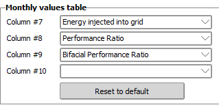
Hi, I noticed that the defaults for the variables shown in the monthly values table of PVsyst reports are now (v 8.0.15) as shown below. I would like to change these to our team's standard variables, but there's no option to show fewer variables. That is, a blank entry doesn't appear in the drop downs. Could we add that back? Thanks, Laura
-
Or one could use the standard "colorblind" color tables. Microsoft has implemented this in the Excel color defaults.
-
Representation of gaps along tracker when using PVcase scenes
LauraH replied to LauraH's topic in Shadings and tracking
Sure, that's how we handled the generic mismatch problem in the past, but it would be nice if it just worked, taking advantage of the CAD system including specific details. -
Hi, Whenever I read in a PVC file for a shading scene, the array area and number of modules shown by PVsyst don't match the array design. After some thought, it seems that the array size is being inflated by the size of various gaps along the tracker: gaps between modules, motor gaps, and potentially joint gaps. Is there any way to correct this? It causes error messages. Optimally, PVsyst would get this information from the PVC file.
-
I have the same question.
-
Report shows spectral correction applied even when it isn't
LauraH posted a topic in Problems / Bugs
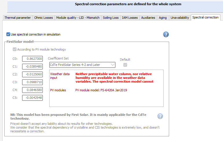
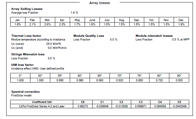
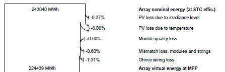
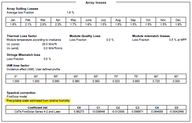
I'm not sure how I never noticed this before, but spectral correction is included in the loss inputs section of a PVsyst report even when the correction wasn't applied due to lack of any water vapor variable in the input met file. In this case, spectral correction is listed but there is no loss/gain listed in the waterfall diagram. I think this is VERY misleading and should be changed. Either take spectral correction out of the input loss list or put an error message where the data source is normally listed. The inconsistency makes it very difficult to figure out why no spectral gain/loss appears in the waterfall diagram when you know you turned on spectral correction. The issue is most likely to arise when modifying an existing project because the user may not check all the previous loss settings. All of the places where the spectral correction could be referenced in a PVsyst run that I can find are shown below for the case when spectral correction couldn't be run along with the input loss pane when RH is included in the met file.
-
Hi, Are we still not able to export SIT files in v. 8? I'm trying to upload a new met file for an existing project but can't pick the appropriate site because it's not in the list. I don't want to create a new site at the risk of changing the model. Any suggestions? Thanks, Laura
-
Hi, When I do a google search on "export PVsyst shade scene to PVC," the AI response is a long message that includes a description of this process, but when I click on the links the same search returns, this process isn't included. I also don't see an appropriate option under "Files" in the shading scene window. I would love to be able save my (updated) shading scenes as PVCs, but I now suspect that this is a case of AI hallucination. Is it, in fact, possible to do this export? If not, can I suggest adding this feature? Thanks.
-
Nevermind. I figured out the problem.
-
I'm trying to load a project I recently ran in v.7 into v.8. I follow the usual procedure: Click on "Import project," then select the project's zip file, as exported. A new window comes up that tells me to "Please choose a zip file containing projects." Why would I have a zip file containing projects inside a project zip file? Do I need to zip the zip file? This makes no sense and doesn't conform to the old procedure. Using 8.0.9. Thanks, Laura
-
I don't think that fully answers the question. Swonno is saying that projects that s/he already worked on in v. 8 don't show up in the list on v. 8. Why should this be? Thanks, Laura
-
I guess it depends on whether you think the degradation rate is a positive or negative number. When I see "annual guaranteed lower limit diminution rate," I think in terms of the magnitude. I believe that the warrantee specifies the maximum amount of degradation you are supposed to see, not the minimum. The minimum would be 0% (least degradation). The graph also shows that the warranted degradation rate is the greatest (largest decrease), but the resulting efficiency is the lowest. Personally, I would buy the modules with the lowest degradation rate. [Maybe this would be clearer if the words "greater" and "lower" were used rather than "higher" and "lower," because the second pair of words implies a direction rather than the overall size of a change? Not sure.]
-
PVsyst Aging _ Clarification on Degradation Calculation in PVsyst
LauraH replied to Kanagavel K's topic in Simulations
Kanagavel -- The degradation used is the average over each year. The important thing is that the warranty is not an absolute value, it is a degradation RATE. So if the warrantee is 0.5% per year, the degradation proceeds as follows: Year 1: 0% to 0.5%, average 0.25% Year 2: 0.5% to 1.0%, average 0.75% Year 3: 1.0% to 0.5%, average 1.25% By the end of each year, degradation has increased 0.5%, so the step from year to year is 0.5% or the warranted rate. Note that, as stated elsewhere, this form of degradation isn't the only one the plant undergoes. For example, module capacity mismatch increases as some modules degrade faster than others. This is accounted for separately in PVsyst. -
PVsyst Aging _ Clarification on Degradation Calculation in PVsyst
LauraH replied to Kanagavel K's topic in Simulations
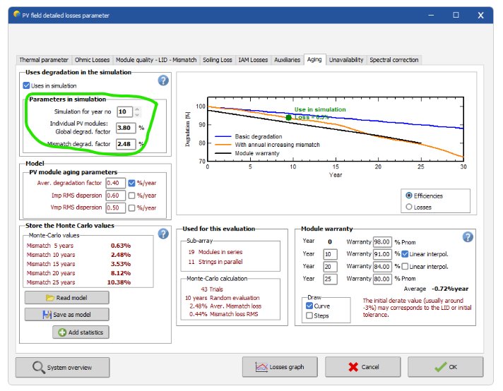
Could you confirm that the only inputs to the degradation calculations are the values circled in green here? I'm assuming that the red values are calculated and the warranty info is only for plotting. Thanks.