Helios210
-
Posts
20 -
Joined
-
Last visited
Everything posted by Helios210
-
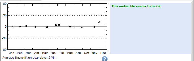
Investigating further it seems generating from MN7 data imported within PVsyst does not present this problem, the graph for best clear days' for December is much better but there is still a significant timeshift and no warning is given this time (??) - see the attached pictures. I have noticed that PVsyst seems to add MN7 data to imported datasets that don't include Linke Turbidity etc. however it leaves GHI and DIFF alone, so I would not expect this to have such a dramatic effect in a single month, though perhaps I am missing something...

-
When using SolarGIS prospect data and the PVsyst synethetic generation algorithm I frequently get: "December has a great discrepancy of time shift with respect to the average." This might make sense if I was using hourly data from SolarGIS but this is hourly data that PVsyst itself has generated! Looking at the best clear days graph for the site clearly shows something wrong for December but I don't know how to fix this. Anyone else noticed similar problems/behaviour? H. Edit 1: Added pictures.
-
If you've gotten this error and still have the splash screen open then there is no need to re-download the software, just open command prompt with admin privileges and execute the following commands in sequence: 1) COPY "%temp%\PVsyst-7.0.14.exe" "%userprofile%\Downloads" 2) Taskkill /F /IM PVsyst.exe 3) wmic product where "description='PVsyst' " uninstall 4) "%userprofile%\Downloads\PVsyst-7.0.14.exe" Then follow the standard installation procedure. Explanation: 1) Copies the installation file PVsyst-7.0.14.exe from your temporary directory where it was downloaded to your Downloads directory in your user folder 2) Stops the current PVsyst-7.0.14 installer which is being run from the temporary directory 3) Uninstalls PVsyst-7.0.12 4) Restarts the PVsyst-7.0.14 installer from the Downloads directory.
-
When saving a geographical site PVsyst automatically generates a synthetic hourly file then asks me if I want to save it. This seems a bit silly, because if the answer is no then I've just waited for it to create something that I didn't want in the first place. A better solution would be to either have a checkbox in the Geographical site parameters dialogue that says 'Generate synthetic hourly profile' or prompt me at the start when I click 'OK' if I would like to generate one. Then if I click 'No' it'll only save the Geographical file, and be a bit quicker about it! :) Cheers, H.
-
When defining multiple sites the meteo information from the last site is loaded, regardless of what file is selected. So, for example doing the following: 1) Create a site for "London PV", import meteo and create a synthetic hourly dataset when prompted 2) Create a site for "Venice PV", import meteo and create a synthetic hourly dataset when prompted 3) Create a new project, select "London PV" and the corresponding meteo file. Setup a standard system and run a simulation. Save the project. Open the meteo file and check the values in Tables > Monthly, it will display the Venice values. I've have a recording of an example where this happens on my system but I can't add it to the post due to the forum rules. Unfortunately the incorrect values carry through to the simulation, so if you're not careful you end up using the wrong irradiation for a site and get sometimes very skewed results... H. Edit: I have done further testing and note this doesn't occur if a synthetic dataset is created manually like we used to do, it only occurs if the automatic generation is selected. Inspecting the .MET files in a text editor reveals the actual values have been swapped, bizarre.
-
While I understand you have no obligation to revert to users' posts on the forum it seems odd to me to have a "Problems/Bugs" section if it is expected that new users implicitly understand this fact. The forums would seem to be a natural place to gather bug reports and then publicly respond for all to see - also saving you having to deal with multiple emails for the same issue - just my two cents.
-
PVsyst Bi-Facial Batch Mode Hourly Report Bug
Helios210 replied to Helios210's topic in Problems / Bugs
Hi Andre, Because the energy is given in W/year, which is absurd for a utility scale system, MWh or MW/year would make much more sense I think. This leads to a very large number indeed which as you can see extends across the page. Best, H. -
There would appear to be a bug for "Produced Energy" in the report generation when reports are generated during batch simulations and use bi-facial modules, please see the attached screenshot for an example. Best, H. See "Produced Energy"
-
Hi all, I am attempting to simulate a bi-facial system using Longi LR6-72 HBD 370 M bi-facial modules. In 6.7.5 this works fine, however in 6.7.6 when "Use unlimited sheds 2D-model" is selected the program hangs indefinitely. Happy to provide any further required information to help you troubleshoot this. Best, H.
-
Wonderful, thank you for the detailed response - that should clear things up quite nicely. Best, H.
-
Hi André, Thanks for the reply - I meant no disrespect! My comment about the erratic nature was more referring to the PlAzim values. This output was achieved using a single axis tracker so I didn't understand why the azimith changed. Thinking on it though I realize that one could interpret it as a change, and the very small 0.00014 value is when the tracker is at, or very close to the stow position - this clears up my miss-understanding so thank you. Best, H.
-
Hi folks, I've had a Client come back to me asking what the 'Extraterr' in the PVsyst SIT file is and where I got it. Since they asked I've checked my other SIT files and sure enough they all have: GlobalH=<13 entries> DiffuseH=<13 entries> TAmb=<13 entries> Extraterr=<13 entries> I thought this might be "extra-terrestrial" radiation - i.e. estimated irradiation before it passes through the atmosphere, but in some cases it diverges rapidly from the GHI readings which I wouldn't expect if this was the case. I can easily explain the other three as these are fairly obvious but I'm stumped with the last one - basically I need to know: a) Does this parameter impact a standard PV simulation (or is it used for concentrating/other solar simulations?> b) Roughly how is it calculated? I don't need a technical description but an outline would be appreciated, i.e. "This is x, it is calculated using y model" - I can then begin to formulate a response to my Client. Thanks all, H
-
Hi André, Thanks for the response, you can get to the dialog I'm referring to as follows: Project design > Grid connected > Advanced Simul. > Hourly data storage I have to reset this for each of my simulations in order to do certain comparisons in PVsyst, it would be much better if I could set a default list of parameters to always be included. Best, H
-
What do the quantities PlAzim and PlTilt refer to? I often get erratic values in my hourly output file such as: PlAzim -90 0.0014 90 PlTilt 40.365 52.692 60 36.509 9.2845 0.0009 What are these numbers indicating? Thanks, H.
-
This is also true for GIncLss, TempLss, ModQual, MisLoss and OhmLoss. Though its' clear these parameters are still being calculated because they are in the report they are not correctly output in the Excel file.
-
Hi folks, I've been going through the settings (unsuccessfully) looking for a way to change the default hourly data storage parameters made when a new variant is created, I want to do this to avoid having to: a) remember to update this list each and every time b) actually update the list! Thanks, H
-
No problem, glad to help, if you come up with a better solution let me know, I'd love to be able to run these comparisons programmatically. Best, H
-
Okay so for anyone else who comes across this I figured out how to do it, its not ideal but its better than a manual check. 1) Open PVsyst, go to "Databases" then PV Moduiles 2) Select the modules you wish to export, hold CTRL to select more than one, I'd recommend doing this in batches of ten as one wrong click will send you back to square 1. 3) Click 'export' - this will copy the data to the clipboard 4) Paste the data into the PVsyst database file located at C:\Program Files (x86)\PVsyst6.7.3\DataRO\PVsyst660_Data\Userdata\Components.xls 5) Use the data import tool to correct any formatting errors 6) Perform your comparisons! Why the module data isn't stored as ASCII like the pumps etc I don't know. This is a needlessly arduous process that I could have circumvented in an hour with Python, but instead I'm forced to use a rather inefficient copy-and-paste method with the GUI - frustrating! In any case I solved the immediate problem, I hope this is of use to someone.
-
Hi all, I would like to check the parameters for a large number of modules across several manufacturers against parameters I have stored in a database (from manufacturer's datasheets). I'm comparing over 100 modules so doing this manually is not really an option. I am able to perform an automated comparison using Python to parse .PAN files which I myself have added, however I have been unable to locate the .PAN files for the modules which are already included in PVsyst. I did find a "PVModuleDB_V6" CSV which looked promising for a direct Excel-based comparison but the file doesn't appear to be human-readable, or the file uses a very strange encoding scheme. I have thought that PVsyst shipped with .PAN files for all the modules used in the program but perhaps this was for an earlier version. Can anyone shed some light on how I might achieve the above?
-
Hello, I've spent some time attempting to understand how PVsyst interprets the .h2p file so I can automatically build them with something like a PYTHON script, this is what I have so far: INSERT 10 - Unknown, seperates panel from ground object if changed 22.467,3.532,6.914 x,y,z co-ordinates 50 - Unknown, causes maximum orientation difference error 90.00 - Azimuth 55 - Unknown, causes maximum orientation difference error 30.96 - Baseline Slope 56 - Unknown, appears to have no effect 0.00 - Tilt DGM - Defines plane as ground object 5.000,0.000 ,6.840; 0.000,5.000 ,9.840;0.000,0.000 ,6.840 0.000,5.000 ,9.840; 5.000,0.000 ,6.840;5.000,5.000 ,9.840 I want to define the plane as a shading object, not as a ground object. I've also tried using Skellion's Export to PVsyst functionality with the same result - I can only seem to create ground objects when I really would like shading objects. Many thanks, H.