avielk
-
Posts
5 -
Joined
-
Last visited
-
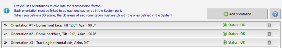
Hello, With version 8.08, I created several orientations ( i.e. Dome + Trackers). I would like to see the output results of each orientation separately, either in the Report or using the Output File function under Advanced Simulations. For example, I would like to see the hourly incident angle of each orientation or the hourly array output for each orientation. I could not find any option for that. Is there a way for that?

-
Several Orientations - Global on collector plane
avielk replied to avielk's topic in Problems / Bugs
I can not send you a project file, but please look at the enclosed two images: Same site; same orientati650 Kwh/Kwp. With second I get 1200 Kwh/Kwp. This is wrong: https://www.dropbox.com/s/m7lziiurlzf23v5/fixed.JPG vs https://www.dropbox.com/s/0crvooech6px512/multi.JPG Avi -
Version 6.25 Description: When using "Fixed Tilted Plane" with a certain orientation, the "Global on collector plane" is correct. When using "Several Orientations" with a certain orientation, the "Global on collector plane" is always 1200 Kwh/m. This is obviously wrong. Avi
-
Hi There-- I am using PVS 6.08 with Win7/64. When creating a new site, I take the following steps: 1. After selectring geographical data (LAT/LONG/ALT/TIME) I import the meteo data from NM6.1. I get certain meteo values (I'll call it SET#1) 2. I would like to compare it to the results using NASA-SSE, so I elect now to import the meteo data from NASA-SSE and overrite SET#1 with the data from NASA (I'll call NASA data SET#2). 3. If I now elect to overrite again the data from NASA by importing the data again from MN6.1, the values are not updated (I still have SET#2), but the header indicates that the data is from MN6.1. soomething is very wrong with this...
-
Hi, I have an installation south of the equator. When I attempt to enter the tilt/azimuth of the modules, I assume that my azimuth should be 180 (since the modules are facing north, and usually azimuth 0 is south). However, the PR that I'm getting is too low. When I try to specify in the Near Shading the exact tilt/azimuth of the table, it is even more confusing as it clearly shows that the modules are facing north - but the azimuth is 9 (which, as I said, mean south). Please clarify if this is a bug, or am I doing something wrong